Kolumbansweg Schweiz
Der Kolumbansweg durch die Schweiz ist Teil des europäischen Kulturweges Via Columbani. Mit der Via Columbani soll der Weg nachgebildet werden, den der irische Mönch Kolumban mit seinen 12 Gefährten am Ende des 6. Jh. von Bangor in Nordirland nach Bobbio in Norditalien gewandert ist.
In der Schweiz und Österreich sind drei Orte in den Lebensgeschichten von Kolumban und Gallus namentlich erwähnt, an denen die Mönchsgruppe sich aufgehalten hat: Tuggen am (damals) oberen Zürichsee sowie Arbon und Bregenz am Bodensee.
Bei der Festlegung des Weges durch die Schweiz gingen wir davon aus, dass zur damaligen Zeit Wanderer den Flussläufen und Römerstrassen folgten. Deshalb war ab Basel der Rhein bis Koblenz, die Aare bis Baden und die Limmat bis Zürich (damals Turicum) nahe liegend. Tuggen konnte ab Zürich mit dem Schiff oder dem Seeufer entlang erreicht werden. Über den Ricken und durch das Toggenburg gelangten sie nach Arbon – St. Gallen wurde erst später am Ort der Klause von Gallus errichtet. Von Arbon nach Bregenz nahmen sie wahrscheinlich das Schiff. Ab Bregenz bzw. Süddeutschland nach Italien existierten Römerstrassen durch das Rheintal und über die Alpenpässe (Lukmanier, Splügen, Septimer). Die direkteste Route führt über die Lenzerheide und den Septimerpass nach Chiavenna.
Wandern auf dem Kolumbansweg durch die Schweiz – Vorarlberg – Fürstentum Liechtenstein
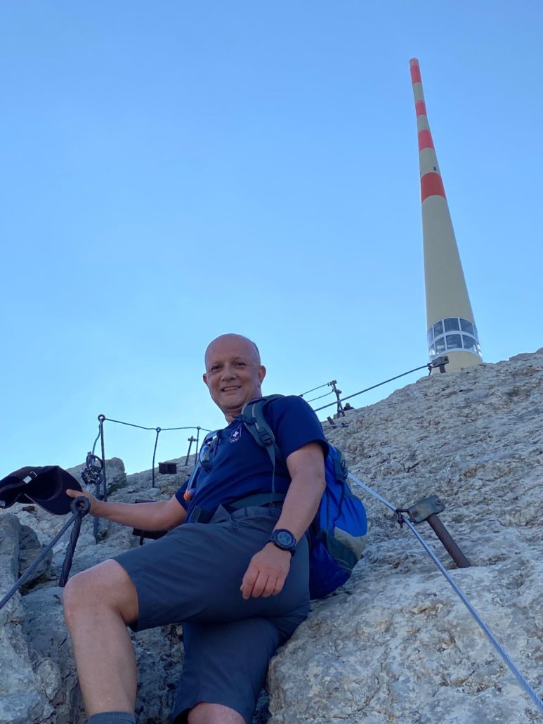
Ich bin Ihr Wanderbegleiter. Ich freue mich, gemeinsam mit Ihnen auf diesem Stück von Basel nach Chiavenna zu wandern. Dabei werde ich Sie auf allerlei Interessantes und Wissenswertes aufmerksam machen. Sämtliche Angaben sind aus der Sicht des von Basel nach Chiavenna Wandernden gemacht. Für Wanderer, die den umgekehrten Weg gehen, gelten dementsprechend jeweils die entgegengesetzten Angaben.
Zuerst mache ich Sie mit der Wanderweg-Signalisation in der Schweiz bekannt.
Der Wegweiser erklärt
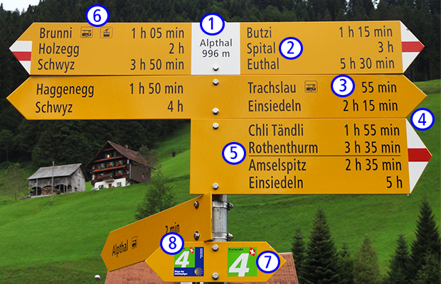
1. Aktueller Standort und die Höhe über Meer
2. Wanderziele
Sind in der gleichen Richtung mehrere Ziele erreichbar, werden die nächstgelegenen zuoberst aufgeführt.
3. Wanderzeit (ohne Pausen)
Zeitangaben finden Sie bei allen Ausgangs- und Endpunkten sowie Zwischenzielen einer Wanderroute. Richtungsweiser (d.h. Wegweiser ohne Zielangaben) dienen der Wegfindung bei Wegverzweigungen und verfügen über keine Zeitangaben.
4. Wegkategorie
Der Schwierigkeitsgrad eines Weges ist dank der Signalisation klar ersichtlich: Es werden Wanderwege (gelb) und Bergwanderwege (weiss-rot-weiss) unterschieden.
5. Trennstrich
Steht im späteren Verlauf eine Routenverzweigung an, wird dies mit einem Trennstrich angezeigt.
6. Symbole
Auf den Wegweisern und Richtungszeigern weisen sie den Weg zu einem öffentlichen Verkehrsmittel, Aussichtspunkt, Grillplatz oder Gaststätte.
7. Richtungszeiger/Zwischenmarkierungen (siehe Beispiele unten)
Diese Wegweiser ohne Ziel- und Zeitangaben (nur gelbe Tafeln) können mit einem Piktogramm (z.B. Wandern) versehen sein und stehen überall dort, wo der weitere Routenverlauf sonst unklar ist. Sie werden durch die so genannten «Bestätigungen» (weiss-rot-weisse Markierungen, gelbe Pfeile) ergänzt.
8. Grüne Aufkleber mit Zahlen und Routennamen
Sie sind entlang besonders attraktiver Wanderstrecken angebracht.
Zwischenmarkierungen
Zwischenmarkierungen lenken Wandernde zwischen den Wegweiserstandorten. Sie informieren über den Verlauf des Weges und über die Kategorie des Wegabschnittes.
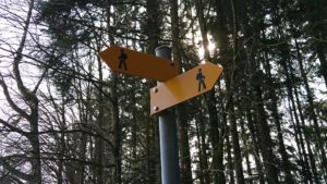
Richtungszeiger
 Die weiss-rot-weissen Markierungen bestätigen den Weg sowie die Richtigkeit der Ausrichtung von Wegweisern, sind aber nicht richtungsweisend. Diesem Zweck dienen auch die gelben Rhomben
Markierungen
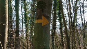
Markierungen sind auf Steinblöcken, Bäumen, Mauern, Pfosten und dergleichen aufgemalte Bestätigungen sowie aufgemalte Richtungspfeile.
Wir werden auf unserer Wanderung insbesondere die grünen Aufkleber mit Zahlen und Routennamen (siehe 8. oben) für folgende Strecken vorfinden:
- Nr. 60 Via Rhenana (unsere Wanderung von Basel bis Koblenz)
- Nr. 4 Via Jacobi (der blaue Rand weist die Richtung nach Santiago, ohne Rand den Rückweg), auf unserer Wanderung von Pfäffikon-Rapperswil-Wattwil, von Tuggen nach Wattwil und von Herisau nach St. Gallen zur Kathedrale. Wir folgen der Richtung ohne blauen Rand
- Nr. 64 Via Sett (unsere Wanderung von Chur über Lenzerheide und Septimer nach Castasegna/Chiavenna)
Für die übrigen Strecken folgen wir den gelben Wegweisern wie oben angeführt.
Öffentlicher Verkehr
Das öffentliche Verkehrsnetz in der Schweiz ist sehr dicht und es finden sich praktisch in jedem Ort Bahn- und/oder Busverbindungen zum nächsten Ort. Fahrpläne können unter www.sbb.ch/de/fahrplan.html abgerufen werden. Busse und Züge verkehren fast überall stündlich. Somit kann eine Etappe auch abgekürzt und mittels Bus oder Zug der nächste Etappenort erreicht werden.
Auch in Österreich besteht ebenfalls ein sehr gutes Angebot des öffentlichen Verkehrs: http://fahrplan.oebb.at/bin/query.exe/dn.